
Points of interest in the Tuckasegee Watershed
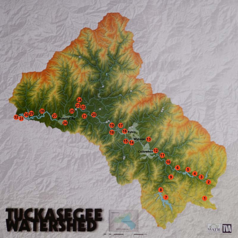
- Panthertown – The East Fork of the Tuckasegee begins where Greenland and Panthertown Creeks merge. Panthertown Valley was purchased from Duke Power by the Nature Conservancy in 1989 and is now a part of the Nantahala National Forest. The valley is flanked by granite domes and features 11 different natural communities, including the rare Southern Appalachian bog.
- Tanasee Creek Lake – The highest and smallest in a chain of four lakes on the East Fork of the Tuckasegee. The 39-acre reservoir is connected to Wolf Creek Lake by an underground tunnel.
- Wolf Creek Lake – Wolf Creek reservoir is the second lake in the chain, and feeds Paradise Falls, a popular 80+ foot high waterfall.
- Bonas Defeat – Bonas Defeat gorge features cascades, sluices, water-formed potholes, house-size boulders, and a 400-foot rock face. Named after a deer-chasing dog who met his end chasing a large stag over the cliff.
- Bear Lake – The largest of the four East Fork lakes, Bear Lake is popular with boaters and features the 120-foot-tall Sols Creek Falls. The South side of the lake is privately owned, but there is public access off NC-281.
- Cedar Cliff Lake – The final lake on the East Fork is long and narrow, and the upstream end has great views of the rock face it was named for.
- Lake Glenville – Built in 1940-41 to provide power for ALCOA’s aluminum production efforts. Originally known as Thorpe Lake in memory of a former president of Nantahala Power and Light, it was renamed in 2002.
- Cullowhee High Falls – A dramatic 100+ foot multi-tiered waterfall downstream from Lake Glenville. High-flow recreational releases are scheduled for seven days each summer.
- Thorpe Powerhouse and Flume – A water pipe that can be seen along NC-107 carries water from Lake Glenville through the mountain to the Thorpe powerhouse at the bottom of the grade.
- Tuckasegee – A small township where the East and West forks meet, and where a Cherokee village was once located. An archeological study of the site informed Bennie Keel’s book Cherokee Archaeology.
- Caney Fork – This valley is the site of Judaculla Rock, which is known for the ancient petroglyphs carved on its surface.
- Cullowhee – Home of Western Carolina University and former site of a Cherokee mound.
- Webster – A popular section of the Western NC Fly Fishing Trail runs through this community.
- Ancient Fishing Weir – This distinct V-shaped weir can best be seen from North River Road. The point of the V is downstream from its mouth; a basket was placed here to catch fish.
- Savannah Creek – After a heavy rain, it is easy to see where Savannah Creek enters the river because of the mud washing down from banks upstream. An old ford, where travelers between Dillsboro and Franklin crossed the river before a bridge was built, was near here.
- Dillsboro/Scott’s Creek/Fugitive Train Wreck/Cowee 19 – Scott’s Creek, which flows from Balsam through Sylva, enters just downstream of the site of the Dillsboro dam and power plant that were demolished in 2010. Downriver, you can see where the train wreck in The Fugitive was staged. Farther downriver, 19 incarcerated laborers drowned in December of 1882 when the raft carrying them to work on the Cowee Tunnel capsized.
- Dicks Creek – Horace Kephart, author of Our Southern Highlanders and Camping and Woodcraft, camped near the confluence of Dicks Creek and the Tuckasegee River after arriving in Dillsboro by train in 1904.
- Barkers Creek – Endpoint for paddlers and tubers going through the Tuck Gorge.
- Thomas Valley – This flat valley is home to farmland and a peaceful, slow-moving section of river.
- Whittier – The river crosses from Jackson to Swain County here.
- Conleys Creek – Location of a 2009 WATR livestaking project.
- Oconaluftee River – The largest waterway entering the Tuckasegee. The Oconaluftee drains a considerable portion of the southeastern section of the Smokies before it flows through Cherokee.
- Kituwah – Regarded as the “Mother Town” of the Cherokees, this was one of the places of the eternal flame. There is a low mound where the Council House is said to have stood. It is a nice place to visit – to walk around and stand by the river whose waters served the town in many ways.
- Coopers Creek – One of the waterways flowing out of the Smokies.
- Deep Creek – Popular camping, hiking, and tubing area in the National Park.
- Bryson City – The seat of Swain County. It was formed in 1871, and originally known as Charleston.
- Proctor – Home of the Ritter Lumber Company, which began logging and saw mill operations in 1910. Now covered by Fontana Lake.
- Noland Creek – A lumber town was established here in the 1880s; also covered by Fontana Lake.
- Forney Creek – The Norwood Lumber Company began operations in the town of Forney in 1910; also covered by Fontana Lake.
- Bushnell – Town established just after the arrival of the WNC Railroad in 1879; also covered by the lake. Named after the Bushnell family of Ohio, who started lumbering operations in the area.
- Confluence with the Little Tennessee River – Here, under the waters of Lake Fontana, the Tuckasegee flows into the Little Tennessee. It then goes on to the Tennessee River, the Ohio River, the Mississippi River, and ultimately to the Gulf of Mexico.
- Fontana Lake – Formed by Fontana Dam, which was completed in 1944 to provide power for the World War II effort.